Tuesday, July 18, 2017

Blue Ridge Parkway-Linville Falls

'If water had adventure parks, Linville Falls would be Six Flags over North Carolina" is what Joe Miller the author of  100 Classic Hikes In North Carolina said about this place. Well, it certainly ranks among the "must see" falls.


 At this, location it's called "Erwins View" of the Linville Falls.


The Upper Falls.


You have the Upper Falls then you have the narrowing of the stream between the boulders that is rapidly falling which is called the Chimney, and the final fall is what you see in the first picture. 


Gorge View. That is a very long ways down.


From the Visitor Center you walk 0.4  miles to the Upper Falls, then another 0.2 to the Gorge View and another 0.2 to Erwins View. This is all up hill with an elevation gain of 145 feet.


 On our way back crossing the bridge just before the Vistors Center we see a fisherman fly fishing. 


Aaron and I have seen many waterfalls and the Erwins View was impressive, but this was somewhat of a letdown due to the fact everything was fenced off. It was all look but no play. Even Gypsy keep tugging at her leash wanting to wade and take a drink in the water but fences and sign telling us "do not go beyond this fence $5000 fine or imprisonment" kept that from happening. 

Monday, July 17, 2017

Blue Ridge Parkway-Fryingpan Trail

At the entrance of the Mount Pisgah Campground is the trailhead of the Fryingpan Trail.


Started about 8:50 in the morning and returned to this same spot at around 12:15 PM.


On a hike like this, I wish I would have something other than a phone camera or a phone with better quality picture capabilities. All these flowering plants were more gorgeous seeing them with the human eye. I can only identify about two, and that would be the Tiger Lilly & Mountain Laurel. I just guess some of the other flowers are maybe Azalea, Dogwood and White Snakeroot.


Can you spot the Mountain Tree Monkey? This part of the trail is a plateau of 5180 feet. We soon descend down to the to the Fryingpan Gap.


After a mile hike through the narrow thick vegetation, it empties out at the Fryingpan Gap onto Forest Service Road 450. Here we take a sharp right and start to ascend to the Fryingpan Fire Tower. It's one of the most impressive views I have ever seen, though the surrounding area with some buildings and weather tower wasn't pretty to look at. But being at a height of  5721 feet plus on a fire tower, the view is priceless. The 6030-foot Cold Mountian to the West looks majestic.


Mountains are so beautiful!


We never had to use bug spray, and Aaron was able to cool off by taking his shirt off and using it as a bandana.


We made it back to our campsite at lunch time, then we spent the rest of our day wading or swimming at the Yellowstone Falls.

Sunday, July 16, 2017

Blue Ridge Parkway-Mount Pisgah

 With a 712-foot elevation gain, the 1.5-mile hike up to the top of  Mount Pisgah (5721 feet) was a real cardiovascular workout. If you are familiar with the Bible, you might recognize the name. Mount Pisgah is the biblical name for the mountain that Moses is said to have seen the Promised Land. 


Woop, there it is! On this side of that tower, we will get a grand view looking westward.


Last three words are "steep in spots."


One of those "steep spots."


Visibility wasn't very good on this day, and we made it back to our jeep just in time before the thunderstorms.


We came, we saw, and we conquered. There is something about climbing to a high elevation and viewing other mountains. You just get this feeling that you accomplished something especially when your forehead and shirt is wet from sweat.


Gypsy had no problem sleeping. On this night she retired early.

Blue Ridge Parkway-Graveyard Fields and the Yellowstone Falls

Traveling down the Blue Ridge Parkway between mile post 418 and 419 you will notice a parking lot full of cars even on a Tuesday afternoon. Aaron and I had been by here on previous occasions and had noticed how popular this spot was, and then we saw a glimpse of some waterfalls in a distant view, and it all became clear why. Most of the people are here to see the waterfalls not to hike the Graveyard Fields Trails. We came to do both.


This big sign near the steps and trailhead give you the full rundown of what you will find at Graveyard Fields. How it came about the unusual name is due to a natural disaster described as a "wind blow" knocked over the spruce forest, and the resulting uprooted root-balls left a permanent mark, eventually covered with soil to give the impression of burial mounds.


The first view of the Yellowstone Falls (I call it a view for lack of a better word because it's more than a view because you can stand right in it.) is what is known as the "Second Falls." The name to me doesn't make sense because it is some smaller falls above the Yellowstone Fall which to me would make it the first falls and the first that you come to.


A look upstream at the Second Falls at a small wading pool.


On top of the Yellowstone Falls


As you exit the stairs down to the fall this is your first view.


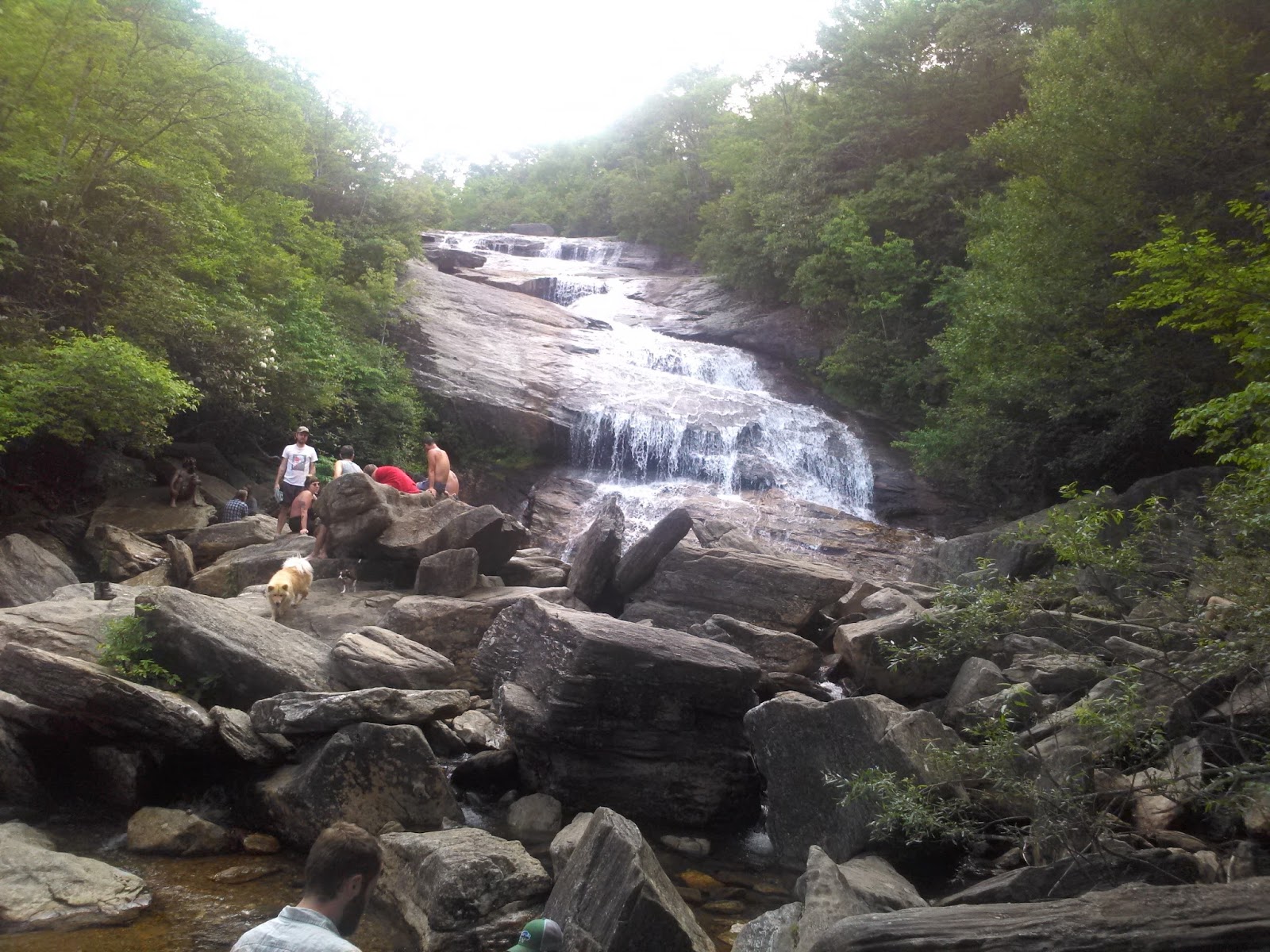
After carefully climbing over the boulders that you saw above; this is the magnificent scene.   


This rock is the closest Gypsy, and I was going to get. Aaron took a dip in the ice-cold water wearing blue jeans. Our revisited the next day he had swimming trunks and swam around at the bottom of the Yellowstone Falls.


We didn't come here just do a short walk to see the waterfalls but came to hike the Graveyard Fields Trail and that we did. Unfortunately, we were in search of the Upper Falls and had thought we might have taken a wrong turn along with another family scratching their heads wondering the same thing. We traveled as a group for a while until Aaron had to tie his shoes and they continued, and we decided to turn back, and we will save the view of the Upper Falls for another trip. We realized after consulting a map we were probably only had a quarter of a mile more to go, but hindsight is always 20/20.


The loop trail back to the parking area we cross over the Yellowstone Prong. The view from the bridge and height is impressive.


Our last view of the Yellowstone Prong from the bridge as we continued walking through grasslands, rhododendron thickets, and over boardwalks. The Graveyard Fields and Yellowstone Falls was an excellent start to a four-day stay in the Blue Ridge Mountains. Luckily for me, I hadn't slipped and fallen on a slippery rock and injured my right hip at this first visit here. I only had to limp along on one shorter hike on our last day.


https://www.youtube.com/watch?v=uynq4Vjoh5U

Copy & paste and go to YouTube and watch the video.

Sunday, July 2, 2017

Nags Head Woods Ecological Preserve

Nags Head Woods Ecological Preserve is the first classic hike presented in Joe Miller's book 100 Classic Hikes in North Carolina. Every vacation I must include at least one trail from this book if the driving distance is reasonable. This forest was just little over a 50-minute drive from our campground at Cape Hatteras.


The sign that lets you know that you have arrived.


It's quite surprising to find a Forest on the Outer Banks. This map shows only the specific trails we hiked, but the map doesn't include all the other trails within the 1100 acre maritime forest.


Throughout the woods is the greenest slimmest algae swampland you will ever encounter. 


Cattails are nothing special to look at, but I have never seen cattails 10 feet plus tall. 


Partridgeberry


Cinnamon Fern


Sweetgum


This American Beech and other plant life including several oaks estimated to be more than 500 years old is just a small sample of what you will see in Nags Head Woods. What you may or may not see but are present within this forest are "five species of salamander, fourteen species of toads and frogs, eight species of turtles, five species of lizards, and twenty species of snakes including the venomous water moccasin and timber rattler. '


The nearly 90-degrees  made this 3.7-mile hike an exhausting affair. Unforturnly I forgot to take a picture of the two other brave souls who went with Aaron and me which was Logan and Kelly. They bowed out after doing the Sweetgum (2) and Center Trails (1). Aaron and I  added the Blueberry Loop Trail (3) to our adventure.


 There is nothing better than to relax and chill out at the campsite after a sweaty hike. Our home away from home was site 399 at Camp Hatteras RV Park.