Sunday, December 13, 2015

Piedmont Environmental Center (North Preserve)

The  Piedmont Environmental Center has two sections. North of East Fork Road is called the North Preserve. Since the South portion of the preserve is nearer to my home, I take most of my after work walks there but usually do my Sunday afternoon strolls up at the North Preserve.


The map above shows the trail system of the North Preserve. It is turned sideways whereas North is to the right and South is to the left.  If you walk the entire outer perimeter as I did, you will have walked 3.45 miles.


The primary access to the North Preserve is parking at Jamestown Park. I prefer to park my Jeep at the dead end of  Sunnyvale Drive and walk 100 yards beyond the gate and begin where the Deep River Trail crosses the road.


This picture shows both my beginning and ending spot. I am parked 100-yards to the right. I can go in either direction and will arrive back at this location in just under 2 hours. 


About half of the three and a half mile walk is on the Bicentennial Greenway. 


 Sometimes I will take a shortcut on the Pinewood Trail. This trail takes you through an impressive stand of pines. This path will shorten the hike by about one mile.


Hiking back on the Deep River Trail I have some gorgeous views of  High Point Lake and will encounter wildlife such as a Blue Herring, beaver,  ducks, and deer seeking a drink.


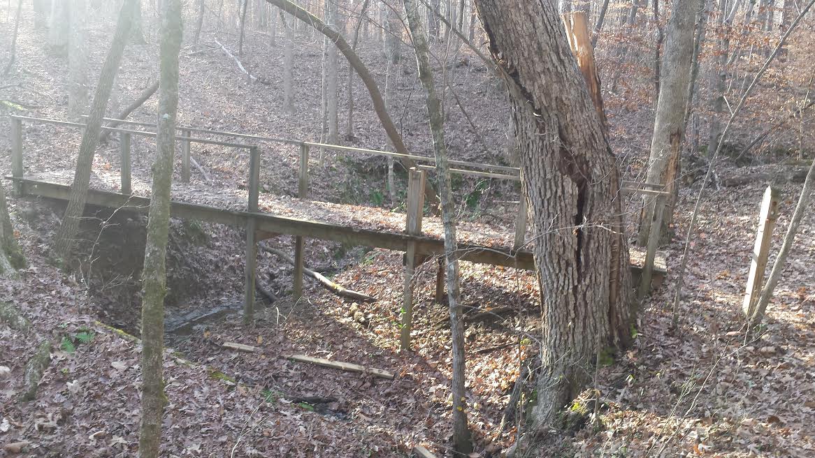
Not only do you have the lake but several creeks that you cross over on some simply built bridges and even a short boardwalk.  At this time of year, there's barely any water flowing.


The portion of the Deep River Trail that circles North of the Greenway will walk you right along the banks a steady flowing creek with plenty of rocks and rapids. 


A large tree recently fell across the Deep River Trail and had been cleared out of the way leaving this tree trunk along the side of the trail. I counted 103 rings that date this tree's beginning to 1912.


This burl probably caused the death of this tree. A burl is a tree growth that the grain has grown in a deformed manner.


Why do mushrooms grow on trees? Here is an answer I found: "Mushrooms that grow on trees bark are spread by wind-blown spores. They usually infect older trees; or trees that have been injured by vandalism, pruning, or storms. Boring insects, high winds, fire, ice, lighting, and snow all can cause wounds that are susceptible to infection by mushroom spores.

Conclusion: The North Preserve is a bit more isolated than the South and less traveled. I enjoy the change of scenery it gives me. Both sections of the Piedmont Environmental Center are a real pleasure to retreat to from the urban sprawl of my everyday surroundings. 

Sunday, October 18, 2015

Blue Ridge Parkway-Mount Mitchell State Park: Old Mitchell Trail


12-miles to the South and 5000-feet lower in elevation the daytime temperature of Marion on this day was a pleasant 73 degrees. At the start of our hike, the temperature was 58 degrees. Despite several reminders to bring his jacket, Aaron forgot his and had to wear my windbreaker.


Entering these group of pines no pine air freshener could of replicate the smell we smelt.


Like so many of my hikes, the trail started out innocent looking then turned into a beast. 


 The most interesting portion of the Old Mitchell Trail was this 10-foot embankment and having to use a rope to help reach the bottom safely.


Aaron is getting ready to lower himself down after listening to some instruction from me.


Instead of following the yellow brick road, we followed the yellow dot trail.


Our mission for this day was accomplished. We can now say we stood on the highest mountain peak East of the Mississippi. 


The floor of the observation platform let you know what direction you were looking.


In each direction, there was a sign with information about what you were viewing in the distance.


The Old Mitchell Trail is a 2.1-mile hike. Normally on my daily walks this distance would take me less than an hour. This 2-mile hike took us twice as long. 

Sunday, October 4, 2015

Hanging Rock State Park-Hanging Rock Trail


 The book 100 Classic Hikes In North Carolina describes the start of the Hanging Rock Trail as a "pedestrian Autobahn" and from the looks of it the author was accurate.


The trail turned from concrete to gravel then the real hiking began starting at these steps. 


Broad wooden steps gave way to narrow rock steps.


As we approached Hanging Rock, the trail became a full blown mountain hike and as strenuous as it can get. Aaron and I took several rest stops along the way including one beneath the rugged base of Hanging Rock.


In the middle of the primary rock of the summit, you see this survey marker. I refuse to wander very far in either direction from this spot. Aaron pleaded with me to take him closer to the edge, but our safety was the utmost concern for me.


Another hiker with his Ridgeback dog bravely peeked over the edge inches from what could be nearly a thousand-foot fall.


After a week of rain and the forecast calling for another week of rain, my Wednesday day off happen to be the only clear day. The North Carolina Division of Parks and Recreation says from atop Hanging Rock you can see Virginia to the North, the Blue Ridge Mountains to the West, Winston-Salem to the South, and Greensboro to the East.


I do enjoy having a human companion with me and especially if it's at least one of my sons. I love my dog Gypsy, but she isn't much of a conversationalist.