Tuesday, September 26, 2023

Itasca State Park - Wilderness Drive

 Itasca State Park isn't just known for the headwaters of the Mississippi, but it was the home of Minnesota's two largest trees. The trees are now dead, and all that's left is the trunks. There are many points of interest on this 10-mile drive through the Park. These are just some that I stopped and took a short hike to see.


Formally the state's largest Red Pine.


Formally the state's largest White Pine.


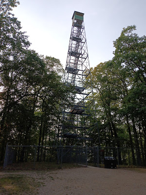
Gypsy climbed to the first platform and headed back down. Even if I didn't have Gypsy in tow, I could have never made it to the top.

Itasca State Park - Mississippi Headwaters

 Within this state park is the headwater of the Mississippi River. It's somewhat of a humble beginning.


These pictures are looking in one direction, then back in the opposite direction. That is the beginning of the Mississippi River!


A neat boardwalk that follows the Mississippi for a short distance.


Here is Gypsy walking across the river and back.


Ashland Waterfront Trail

 I illegally slept the night in my van on September 7th at Lakeview Park in Ashland, WI, but no one bothered me. It's always nice when a city provides scenic walks for their residence nearby or alongside the most beautiful part of the area. 


This is the view of the Chequamegon Bay of Lake Superior from the Waterfront Trail. It provided a nice evening leg stretch from a long drive and a peaceful morning walk before we headed back on the road for our next destination. In the distance is the "New" Apostle Light, a breakwater light for the Apostle Islands.


Grass River Natural Area

 Grass River Natural Area is a 1,492-acre nature preserve near Bellaire, MI. I did this hike on September 6.


The natural area has 7 miles of loop trails. I could only hike Algonquin and Nipissing Loops because, unfortunately, heavy rains moved in, and I could not walk the 1.5-mile Sedge Meadow Boardwalk Loop. 


This is a typical view of the trails.


It's always lovely when trails are well-maintained and have maps to show where you are. I will revisit here again since it isn't too far from my family burial plots at the Clearwater Township Cemetary.

Babcock State Park

Babcock State Park's main attraction is Glade Creek Grist Mill, a fully functional replica of the original Cooper's Mill.


Thousands of people have taken this exact photo. It's really a sight to behold.


Further downstream, you see a little waterfall.


West Virginia's natural beauty is a good replica of heaven.


The only hike I took here was a short 1/2 mile morning hike along the Skyline Trail on September 4. This view can be seen from the trail or driving your car to this spot.  


Monday, September 25, 2023

Lone Oak to Tip Top Trail


This hike was done in the afternoon of September 2. You drive past the trailhead to a small dirt parking area on the opposite side of Dry Creek Road. This sign is a short distance down the trail as you follow a tributary off from the Sinking Creek.


The elevation gain is 1276 feet, with many switchbacks to help with the climb.


Your climb is rewarded with a picnic table and a bench for resting and viewing the vista view of Johnson City, TN.


The first photo is a magnified photo of the view, and the last is an actual one. The two-mile return trip was so much easier and faster. We spent considerable time resting and ate lunch at the top. Our total time was 3 hours 25 minutes. Total distance:e 4.09 miles.

Monday, October 31, 2022

Pere Marquette State Trail

The Pere Marquette State Trail ends or starts 2.3 milses West of the city of Clare depending on what direction you're traveling; at what is called the Moose Lodge Staging Area.There is approximately three-mile section that has not been built through the city called The Clare Gap. All together the trail is 56 miles long on the former midsection of the former CSX Railroad line.


 Gypsy and I didn't do a very far walk on this day because it was so hot, and the trail didn't provide much shade, starting at the Moose Lodge Staging Area. We walked maybe a mile and turned around. 


I drove West on US 10 and pulled off at Riverside City Park in Evart. There was this iron bridge that crossed over the Muskegon River.


This is the view of the bridge from the fishing pier at Riverside City Park.


The Muskegon River view in the opposite direction from the bridge, looking downstream on the fishing pier. 

A bicycle is probably the best way to enjoy the Pere Marquette State Trail.