Just 6 miles Southwest of Asheboro, NC sits the Birkhead Mountain Wilderness Area on the Northern edge of the Uwharrie National Forest.
An April 2013 Spring Break vacation brought me to these woods. Not having an accurate knowledge of the length of the trail system, I came ill-prepared having only three bananas and 40 ounces of water. I did have a compass that was a tremendous help considering I didn't have a map.

A Bridge is crossing over the Robbins Branch Creek.


This portion of the trail acted as a funnel for rain water runoff.
.


The parking area is off of Lassiter Mill Road. I first walk through an old abandon homestead, passing the house and outbuilding on a two-track.
After I cross the bridge over the Robbins Branch Creek, there was a scenic view of that river from up high on the river bank. The two-tract soon disappears and becomes a footpath has you enter the forest.
The first intersection sign I came to was confusing with arrows pointing in all directions, even towards where there was no trail. Straight was the correct direction to go.
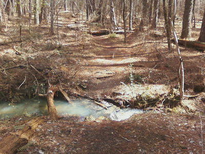
Throughout the wilderness area, I cross over several streams with no bridge. Some I easily leaped over, but others I couldn't avoid getting my feet wet. The large creek pictured above, I lost my phone in and found it an hour later submerged. I had put my phone in my chest shirt pocket, and it fell out when I tried to leap from one embankment to the other.
Near the junction of the Birkhead Mountain and Hannah Creek Trail is the most intriguing sight. I'm not sure why a chimney would be in the middle of the woods, but it sits tall on the ridge like a monument. Since my phone camera was no longer working, I borrowed the photo above from the Birkhead Facebook page. As you can see, this picture was taken in the summer.
If it wasn't for being exhausted and the stress from feeling lost, the beauty that surrounded me could have been enjoyed much more. If it wasn't for my compass, I might have given up trying to complete hiking the entire wilderness area.
After 6 hours and 10 minutes, my dog and I were back to the Jeep. According to the USFS map, making the circle from the Thornburg Tailhead is a 7.2-mile hike. Counting the extra hour it took me to search for my phone my total hiking distance for this day came about 9-miles.
A few lessons I learned was: first, never go without a map. Second, take more energy food and water.
I plan to come here again since it is only 30 minutes from my home. I like to take some pictures of the homestead and the chimney.
.
No comments:
Post a Comment